3.2 Examples of Nature-based Solutions
NbS can be implemented in: coastal areas, rivers, cities and lakes. Bellow we present few implemented NbS examples of each these locations and their benefits.
Coasts
Coasts are highly dynamic zones that hold a great importance for society, the economy, and the environment. Coasts support thousands of communities across the world who rely on the ecosystem for the services it provides for their livelihoods. From sandy shores to muddy mangrove forests, the value of coastal environments can not be overlooked.
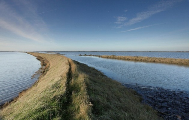
Wallasea Island Wetlands in Essex, England
The challenge: Development along the coast has led to habitat deterioration 86 hectares of wetland were lost along the banks of Lappel in the Medway estuary and at Fagbury flats in the Orwell estuary due to port construction and associated development. The loss of vital habitat has a dramatic impact on the species that depend on it for survival. The area is also at risk to flooding due to the erosion of the existing seawalls.
The goal: Create wetlands that serve as habitat, flood protection, and recreation. The main goal of the project is to create coastal wetland habitats for wildlife diversity. In addition, to avoid flood risks due to the deterioration the existing seawalls on the island, and to create an extensive area of accessible coastal land for the quiet enjoyment of nature and open space for recreation.
The solution: Managed realignment with re-cycled sediments to create wetlands. Dredged material from a near-by port was deposited behind the seawall to create salt marshes. The re-cycled sediments were used to build a new, higher wall inland from the pre-existing one. The salt marshes and the new seawall form an integrated flood protection system. After this, the old walls were breached to allow water at high tide to inundate the land and to let mudflats and salt marshes evolve naturally.
The result: Successful development of habitat. Upon completion, the final phase will add 269 hectares of wetland to the 514 hectares already restored at Wallasea island since the beginning in 2006. The project has led to the formation of the largest man-made wetland in Europe. This new landscape serves as a breeding and feeding ground for a variety of bird species, such as spoonbills and Kentish plovers. The project is due to be completed in 2025.
Source: NbS platform
Rivers
Rivers are the Earth’s conveyor belts, which collect and transport excess water and sediments from the land to the sea. Through this transportation, they create their own shapes through processes of erosion and sedimentation. Rivers are dynamic and hold a highly intrinsic value for the natural ecosystem, as well as the people that depend on them.
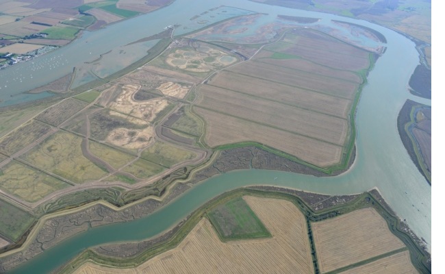
Cache la Poudre River in Fort Collins, Colorado
The challenge: Land use changes in the river’s historic floodplain including gravel mining and urbanization diminish the river’s ability to scour and deposit sediment within the river channel and constrain flooding events onto the floodplain that nourish riparian vegetation with water and vital nutrients. Likewise, growing water demands to support agricultural and municipal needs have modified the river’s hydrology through alterations in base flow, timing and duration of flooding events, and negative physical and chemical changes in low flow periods (<0.85 cubic metres/second). Finally, regional climate change predictions complicate our ability to understand how the river’s hydrology and ecology may respond to warming climate scenarios.
The goal: The primary goal for the Sterling Pond and McMurry Restoration projects was to remove high, artificial banks created along the riverbank during gravel mining operations, which sought to prevent river flooding during mining activities. As a result, the river and its natural processes became highly modified and dysfunctional. Unnaturally elevated banks disconnected the river from its floodplain, increased bank erosion due to increased shear stresses resulting from channel confinement, and eliminated bankside vegetation and habitat. Recently, the formerly common approach of creating channelized rivers with armoured banks has given way to the idea that surface and groundwater interactions within the river ecosystem (river channel, riparian forests, and associated wetlands) is necessary to sustain river health and habitat while providing for optimal water quality (filtration) and increased water quantities.
The solution: Planting native wetland vegetation and floodplain trees and shrubs was included in the restoration plan, because the riparian forest had been nearly lost due to the lack of flooding flows which nourish the floodplain with water, nutrients and sediment. Five diverse vegetated zones were created – emergent wetland, wet meadow, willow, cottonwood, and upland grasslands, all intended to increase native species diversity and enlarge the riparian forest. To facilitate public use and stewardship of the site, the project design included a pedestrian trail and designated fishing areas. Today, the property offers Fort Collins residents and visiting tourists a wealth of recreational opportunities.
The result: Together, the two projects restored two kilometres of the river’s channel and riverbank, created over five hectares of riparian floodplain forest, and several hectares of wetlands. The projects planted an astounding 1,200 trees, 25,000 shrubs and 60,000 wetland grass plugs. Both projects included removal of hard infrastructure reconnecting more than 1,500 metres of river with its floodplain. Removing the Josh Ames Diversion Structure resulted in multiple ecological benefits including lowering river water temperatures, eliminating fish barriers, and enhancing public safety for recreational float boating. The projects also incorporated a number of recreational features. The City’s Natural Areas Department was responsible for the location and development of trails and river fishing access points within the project area. At McMurry, a series of boulders placed at approximate water elevations were placed to help visitors understand the importance of functional floodplains, and the necessity of high river flows to spill out of its channel.
Before and after dam removal at Sterling Pond restoration site. Source: IUCN
Cities
Cities are living environments that are constantly changing, shifting, and growing over time. By 2050 close to 70 % of the world’s population will be living in a city. The physical, social/cultural, political, and ecological dynamics of a city differ all over the world. Due to these differing dynamics, solutions to challenges need to be applied at the local level where the individual dynamics can be understood and sustainably addressed.
Green Infrastructure and Biodiversity Plan, Barcelona, Spain
The challenge: Barcelona is one of the most densely populated European cities with about 1.62 million people living in an area of just over 100 km2. Air pollution has become a major concern for residents as the city has regularly exceeded the European Union’s limits for average annual concentrations of nitrogen dioxide and particulate matter over the past decade. In addition, changing land use has reduced the city’s green space and biodiversity and limited the connectivity of its natural areas. During the past five decades, the city has converted rural land to urban use at a rate of about 1,000 hectares per year. Rapid urban and industrial sprawl in the Barcelona Metropolitan Area, together with traffic infrastructure development, has caused habitat and landscape fragmentation, resulting in thousands of patches of isolated natural areas with minimal ecological function. Furthermore, municipal land-use and urban plans often do not consider functional ecological processes when incorporating protected natural areas in city plans.
The goal: The 2020 Barcelona Plan aims to create a city where natural heritage and biodiversity are preserved and enhanced, where maximum green infrastructure (GI) and connectivity are achieved as well as maximum social and environmental services from GI, and a city that is more resilient in the face of climate change. Restoring and enhancing GI through this plan provides the inhabitants of Barcelona with many ecosystem services such as air purification, noise reduction, regulation of urban climate and temperature, reduction in energy consumption and CO2 emissions, water cycle regulation, recreation, improvement in mental health and general well-being. In addition to these benefits to humans, GI supports biodiversity, provides habitat for flora and fauna, and creates ecological connectivity.
The solution: Barcelona City Council developed the plan using a participatory approach. Several meetings were held in early 2009 to discuss the assessment of GI in the city, agree on long-term challenges and goals, and gather proposals on a way forward for enhanced biodiversity and GI. Participants included multi-level government representatives, researchers and social, environmental and private institutions. A 2008 citizen opinion survey also determined that green areas were associated with health, freedom, nature and relaxation and that citizens wanted to see more flowers, trees and lawns as well as increased cleanliness and security in these areas. A number of different strategies were developed to achieve the goals set out in the Plan. Examples of these strategies include: managing parks, gardens and other green spaces to reduce the demand for water, control for pests and disease, and use suitable soils; improving knowledge of how climate change is transforming the environment; developing a communication strategy to spread knowledge of GI, biodiversity and their values; promoting citizen involvement in the creation and conservation of green spaces for health and enjoyment; and building strong local leadership, networks and commitment to conservation of GI.
The result: To date, the Plan has launched numerous education and outreach initiatives as well as GI activities. Positive impacts have already been seen as a result of these actions.
- Education and outreach initiatives. Several programmes have been launched to improve public knowledge and appreciation of the benefits of GI and biodiversity, and the need for conservation. Annual gardening workshops for families are offered in parks and gardens in the city. Schools use parks to learn about sustainability through the city’s ‘Come to the Parks’ programme. Scientists facilitate exploration of the city’s flora and fauna every year through an event called “BioBlitzBcn”. The goal of this event is to identify and count as many species as possible in a specified area. During the most recent BioBlitz in April 2016, almost 1,000 scientists, naturalists and volunteers identified 249 species at Montjuïc Hill and Barcelona’s Botanical Garden.
- GI activities. Many GI initiatives are underway. For example, the designation of maintenance levels for various green spaces is under review to optimize resources and maintenance. More resources need to be allocated for maintenance instead of regeneration or full renewal of areas. Controlling leaks in pipes, use of groundwater, automated irrigation, and the use of plants with lower water demands has decreased the pressure on drinking water. Ten thousand tonnes of plant material from pruning and maintenance activities have been transformed into mulch and compost, which are reused in green spaces. Through the ‘Plan of Vacant Urban Plots’ programme launched in 2012, NGOs are converting vacant city-owned areas to places for GI activities such as gardening and urban horticulture to provide spaces for recreation, social integration, maintenance of cultural heritage and access to food.